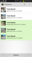


PhotoMon

Description of PhotoMon
One of the simplest and unambiguous ways to detect environmental change is by taking regular photos of exactly the same place over time. This process, known as photo-monitoring, can be used to document change in a wide range of situations; from seasonal growth of plants in a garden to changes in vegetation over broad, sweeping landscapes. It is also useful for recording change in beaches and rivers.
This app assists anyone wanting to monitor environmental change by making the photo-monitoring process much easier and more accurate. It achieves this by incorporating features aimed at streamlining processes for field monitors and project managers, whilst improving the quality of data. These features include:
• Overlayed transparent reference photos for consistent field-of-views;
• Automatic date and site labelling;
• Reminder function to prompt regular photos.
When configured to connect to a photo-storage database the app can greatly assist larger photo-monitoring programs via:
• Automatic uploading of monitoring photos using cellular network or wifi;
• Enabling program coordination via the database.
Photomon has flexible options for a range of photo-monitoring applications:
• “Demo” mode allows the app to operate as a stand-alone tool suitable for use by individuals and small groups;
• NACC currently operates the app configured to a dedicated database, please see the “Info” page in the app for further details;
• Photomon is covered by the GNU General Public License and as such can be altered to facilitate connection to a different database, please see the “Info” page in the app for further details.
Download this FREE app and start monitoring today!
The app has been developed by the Northern Agricultural Catchments Council (NACC) with funding from Coastwest.


